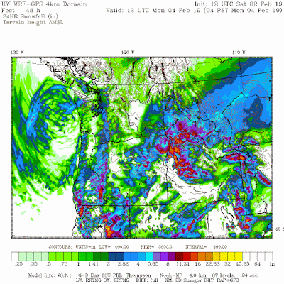
The bottom line is that it is becoming increasingly likely that light snow will fall over the portions of the lowlands of western WA, including the central Puget Sound region.
Let's start with the latest high-resolution WRF forecast for snow, covering the accumulated snowfall for the 24 h ending 4 AM Monday. Lots of light snow associated with a low center moving down the coast, with substantial variations.
But let's look closer over western WA. There is a north-south band of snow of 2-4 inches that crosses over Seattle. This is associated with what is often called a "deformation band" and I would not bet my life on its exact position. A small area of heavier snow is found on the north side of the Olympics, associated with strong NE flow from the Fraser Valley being forced upwards by the Olympics.
The accumulated precipitation by the lower resolution European Center model is found below... it is also showing a N-S snow band, but displaced a bit to the east.
So the single-solution deterministic forecasts show a threat of lowland snow. But there is plenty of uncertainty in this forecast, since everything is dependent on where the coastal low moves and where the snow band sets up. The way to handle that issue is to turn to high-resolution ensembles, running the models many times with slightly different initial conditions and physics to see how robust the snow solution is.
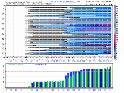
We are fortunate in the NW to have perhaps the best high-resolution ensemble system in the country thanks to the support of the NW Modeling Consortium (a number of state and local agencies) and those that contribute to the effort through this blog. Here is the snow prediction for Seattle from our ensemble system from last night's run. There is a lot of variability (thus uncertainty), with the ensemble mean (probably the best single forecast) of a little over 1 inch (note that time is in UTC/Z---standard time at the Greenwich Meridian). I suspect the next ensemble forecasts will be higher.
The ensemble forecast for Seattle temperatures show less uncertainty, with a slide to below freezing on Monday morning (note 12Z/04 is 4 AM on Monday)
The ensembles are also confident that all hell will break loose in Bellingham, with strong northeasterly winds developing tomorrow and associated very cold temperatures.
What about the European Center ensemble, which is relatively coarse? Most of the members are going for light snow Monday AM in Seattle, with the average about 1 inch (see below)--but note the much bigger event later in the week.
In summary, tomorrow cold air will move into the region (see my previous blogs for more on this), with temperatures dropping below freezing Monday AM. Strong winds over NE Washington developing on Sunday. And some lowland snow is likely Monday morning....but no more than a few inches. But there is plenty of uncertainty regarding the exact amounts and distribution.
I suspect Seattle, WSDOT, and others will prepare by doing some pre-treatment of roadways on Sunday, which will prevent an ice build up on critical roadways. The homeless folks need to get inside. The commute on Monday may well be affected. But thank god we have the new tunnel in Seattle-- no snow problem there!
No snow here!
from Cliff Mass Weather and Climate Blog http://bit.ly/2G3IUyV


No comments:
Post a Comment