First, proof of the snow is found in several of the WSDOT cams around Bellingham (see below).
And this video from Lyndon, WA looks like something from Siberia:

A plot of the observations around Bellingham shows the the strong, cold northeasterly flow coming out of the Fraser River Valley. At Lyndon, the temperature was 22F, with gusts to 34 mph. It will get worse there.
If you really want to be impressed, here is a more regional view, with temperatures way below zero (black numbers to the upper left of the circles are temperature) in the BC inteior, with very strong northeasterly winds (gusts to 82 mph) pushing offshore north of Vancouver Island. These winds are driven by the strong high pressure over the interior of BC..the same high pressure that will push cold air into NW Washington.
As the cold air pushes offshore it passes over the relatively warm waters of the eastern Pacific (around 50F), resulting in a big change of temperature with height and instability, which in turn produces lines of cumulus-type clouds (see below) that grow and are circling towards us. A cyclonic circulation/low pressure area is developing offshore.
So what about snow?
The latest UW high resolution forecast for the 24 hr ending 4 AM Monday shows perhaps .5 inches of snowfall over central Puget Sound (remember snowfall is NOT necessarily snow accumulation). MUCH more over the northern side of the Olympics and heavier amounts (a few inches perhaps) over some areas of SW Washington and around Bellingham.
The next 24-h shows drying to the north and a bit of light snow over Seattle and and to the south.
(and more on the north side of the Olympics).
Looking at last night's high resolution ensemble forecasts of accumulated snowfall (a UW exclusive!), we see huge variability in the snow forecasts (thus lots of uncertainty), with the average (dark black line) of about 1 inch.
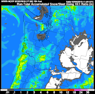
The latest NOAA/NWS high resolution rapid refresh model (HRRR) total snow total through 3 AM Monday has .1 to 1 inch over Seattle, with more over NW Washington, the northern Olympics, and the coast.
Temperatures will really cool down now, with highs tomorrow in Seattle to the mid-30s (see Sea-Tac ensemble temperatures below) with lows in the 20s on Monday night.
Bellingham will be something else, with lows dropping into the tens. Accompanied by strong winds, the region north of Bellingham will have wind chills way below 0F.
Bottom line: The air has started to cool above us and is rapidly becoming cold enough for snow.
The big problem is lack of precipitation...this is NOT a wet system for us, partially because the upper trough and low center is too far offshore. Temperatures will cool below freezing tonight in Puget Sound and even cooler Monday night/Tuesday morning. Snow amounts will vary greatly, but generally will be light. Seattle will get perhaps .5 to 1 inch of snowfall, but accumulation will be hampered by our generally warm roadway surfaces. But don't be shocked if central Puget Sound gets very little or a bit more....there is substantial uncertainty in this kind of forecast.
from Cliff Mass Weather and Climate Blog http://bit.ly/2DSxCey


No comments:
Post a Comment