After a period of relentless rain and wind, much of the Northwest will experience a wonderful break, with several days of dry conditions, sunny skies, and light winds. And to add to the experience, sunset is now perceptibly later.
This morning's sunrise says it all.
But if you really want to be optimistic, here is the forecast accumulated precipitation through 4 PM Tuesday from the UW WRF modeling system. Washington and Oregon are dry, in contrast to a sodden California.
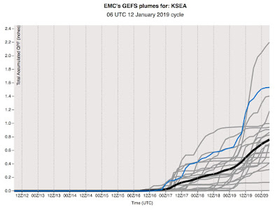
But can you trust this forecast? Let's check the NWS/NOAA GEFS ensemble system (running the model many times to explore uncertainty) for Seattle accumulated precipitation (see below). Yes....all the members of the ensemble are dry through 4 PM on Tuesday. You can take this forecast to the bank.
What about sun? Expect a lot of it. Here is the cloud forecast for Sunday at 1 PM. Cloud-free conditions are predicted.
Why will the northwest have such a nice break? Because of major ridging (building of high pressure) over the western U.S. with the jet stream (and associated storms) heading into California. Let me show you with a series of upper-level (500 hPa pressure, about 18,000 ft above sea level) charts to illustrate.
7 AM today. A ridge centered to the east of us, with a trough offshore that could bring a sprinkle to the coast, but not much more.
4 PM Sunday. Wow.. huge ridge builds over our region.
Monday at 4 PM...still there.
And at 10 AM Tuesday, the ridge is starting to pull back, but still enough to keep us dry and sunny.
You might notice that a lot of action is going into California. While we are dry, they are going to get pummeled with heavy rain and wind.
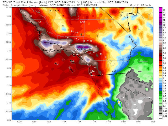
Take a look at the 7 day forecast precipitation totals for southern CA from the European Center model. Some amazing totals (as much as 10 inches in the mountains there). There won't be much drought talk when this is over.
This situation is classic El Nino, with the jet stream heading into southern CA. So if you were planning a trip to LA to dry out...cancel it. Stay here for sun and dry conditions.
A break like this in mid-winter is a godsend for those bothered by darkness and clouds. And keep in mind that our meteorological spring is only 5 weeks away.
from Cliff Mass Weather and Climate Blog http://bit.ly/2SQqdS1


No comments:
Post a Comment