With new year's coming up tomorrow night, it is appropriate to look back on the weather of the past year.
The essential take away: 2018, and particularly the late spring and summer, were much warmer than normal.
We can illustrate this with a nice graph (see below) produced by the National Weather Service for Seattle-Tacoma Airport, showing the observed temperatures (blue line), the normal range (green shading) and the records for each date (high records-red color, low records, blue color).
One is struck immediate by the many dates that were above normal, particularly from May 1 to Sept. 1). A number of these days hit highs 10-15F above normal. On the other hand, the annual extremes were not impressive...on day got to 94F and the lowest temperature all year was 24F, with only one cold spell in late February.
Precipitation was a very different story--the annual precipitation will end up slightly below normal (see middle graph, top of light green shows accumulated precipitation), resulting from a wetter than normal first half of the year, a dry summer, and moist late fall.
Snow in Seattle was almost absent: about 1 inches compared to a normal total of around 6 inches.
A regional view of the differences from normal of temperature and precipitation for 2018 is shown below. For temperature, the entire region west of the Rocky Mountains has been warmer than normal, particularly the U.S. Southwest. Here in WA state, roughly 1-2F above normal. But note the cooler than normal weather over the northern Plains. That will be important.
Precipitation is more complex. Most of the west was near normal in 2018, except from southwest WA to northern CA, where is has been quite dry. The contrast across western WA is really substantial.
So what it the cause of the warm anomaly in the West?
Anthropogenic global warming might be making some contribution, but there is much more going on. A hint at this comes from taking a broader perspective, looking at all of North America (see below). This figure shows the temperature anomaly (difference from normal) for 2019. Blue indicates colder than normal and red/orange above normal. The western U.S. is warm, but the middle of the country is cold, while the East Coast is warm.
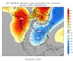
This pattern was associated with an amplified upper-level wave pattern, with ridging (high pressure) over the West Coast, with troughing (lower pressure) over the central U.S.. This pattern was evident for much of the year, including our warm/dry period in November and during the late spring.
To illustrate, here is a map produced by the National Weather Service showing the average upper level (500 hpa) height anomaly in November (sorry it is blurry, the government shut-down makes it impossible for me to get better graphics). Red indicates higher than normal heights (ridging), blue indicates troughing). Ridging produces localized warm surface temperatures, the opposite for troughing. Ridging also suppresses precipitation, explaining our drier than normal conditions.
There is no reason to expect that this pattern has anything to do with global warming (note: the "lazy jet stream" hypothesis has been firmly disproved in the peer review literature).
How much of our warm year might be due to anthropogenic global warming? We can get some insights into this by using the wonderful Washington State Climatologist climate plotting site (with kudos to Karen Bumbaco and Nick Bond). The annual temperature in Seattle is shown below. A small upward trend of perhaps .5F, with human caused global warming undoubtedly contributing during the past 30 years. Other local stations are similar.
The take away is that most of the warming this year (1-2F) is due to the anomalous upper level pattern, which is probably the result of natural variability. Why am I stressing this point? Because too many people, and unfortunately some in the media, make the assumption that every warm anomaly is mainly the result of increasing CO2 in the atmosphere. This is simply not true.
from Cliff Mass Weather and Climate Blog http://bit.ly/2Sr4Oi0


No comments:
Post a Comment