But in general, Seattle has been left out of the bounty, even though we are cold enough to snow. More snow north, south, east and west of us. But why are we being short changed?
There IS a reason.
Let's start by showing the distribution of snow depth last night at 10 PM from the NOAA National Snow Analysis. Yes, there is a bit more now, particularly over NW WA and the coast. On the left, is last night and on the right, 10 days ago.
Quite a bit more over the west lowlands, particular south of Olympia, and east of the Cascade crest. But not much over Seattle and south King County.


A year ago? More snow than this year over the Oregon Cascades, less over the western lowlands and slightly more over the WA Cascades.

So why has snow been generally light or absent over central Puget Sound?
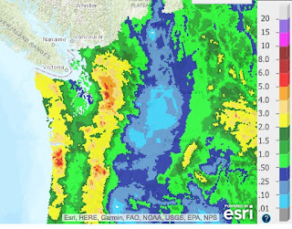
A major reason: winds in the lower atmosphere have been too persistently out of the Northwest, leaving Seattle in the rain shadow of the Olympics. To illustrate, here is the National Weather Service precipitation analysis for the last week....lots of precipitation in the mountains, but major rain shadowing over Puget Sound. And with cold air over us, that means snow shadowing as well.
Another issue is that the atmosphere is relatively dry west of an upper level ridge--and that is the pattern we have had for days (see map).

Only when a strong trough works its way around the ridge and drives southward can we get real snow in Seattle in such a situation.
Getting back to the current snow situation....snow should end during the next few hours as the upper trough moves by. Thursday should be dry.
But we have another chance of snow on Friday, as two weak disturbances make their way south from SE Alaska to our region on Friday/Friday evening, and another on Sunday (see upper level maps for these times).


There is a good chance for light snow over the lowlands on Friday...and much more in the mountains. Here is the European Center high-resolution 24-h snow total forecast between 10 AM Friday and 10 AM Saturday. Over a foot in the mountains and about an inch in the lowlands.

In their ensemble (many model runs), the Seattle accumulated snow forecast starting 4 AM this (Wed) morning shows the light snow today (good prediction of about a a half inch), but more (about an inch) on Friday. I should note that there is some uncertainty in the exact amounts, but some snow looks likely.

So at this point, no big snowstorm in view (at least through Saturday), but enough to think about getting that hot chocolate and enjoying the flakes.
from Cliff Mass Weather and Climate Blog http://ift.tt/2HBdhKp
No comments:
Post a Comment