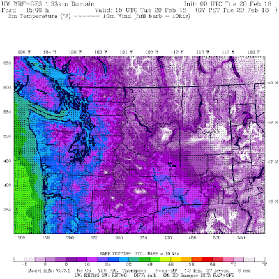
The surface air temperatures last night (see below) were held up by the windy conditions (which mix down warmer air above the surface) and some clouds, but still temps dropped into the mid 20s F in much of western Washington and single digits in the mountains Some valley locations dropped below 0F. Teens dominated in eastern WA.
Tonight is going to be much colder, with colder air aloft, clear skies, and less wind. The temperatures predicted for tomorrow morning suggest mid-20s in the west and single digits east of the Cascades, with some valleys in eastern WA dropping below -8F.
The latest forecast model output predicts another four days of the really cold stuff. Here is the NWS GEFS ensemble forecast for Seattle. Several more days of lows in the mid-20s ahead.
The large scale atmospheric pattern is really locked into a super La-Nina configuration with high pressure offshore and cool northerly flow over the NW. To show you this, here are the upper level (500 hPa) weather maps for Wednesday and next Tuesday. Quite similar really.
There are occasional disturbances moving southward in to the flow east of the upper level ridge of high pressure that will bring some occasional precipitation, and in some places, snow.
To illustrate, here is the total snow fall forecast for the next 72 h. Most of the snow is heading for Oregon and SW Washington. None over Seattle or the WA Cascades.
The next 72 hour is quite different, with massive snows in the WA and Oregon Cascades. Skiers will be pleased.

Keep warm....
from Cliff Mass Weather and Climate Blog http://ift.tt/2C7XCCO


No comments:
Post a Comment