A graupel storm.
Small white pellets starting coming down, first slowly and then in an immense wave in places, piling up until some locations had accumulated ..5 to 2 inches of the white balls.
Here is a nice video by Jamie D. that shows the fun:
Now some folks caled it hail and others thought it was sleet. But it really is graupel, and was caused by a strong Puget Sound Convergence Zone working on unstable air.
First, what is graupel? This is what they look like close up. White pellets. Relatively soft. Opaque.
Graupel is heavily rimed snow crystals. Snow crystals form in clouds whose temperatures are generally cooler than about -15C. At lower levels, where the temperature is warmer, but below 0C, there can be supercooled water (liquid water that is below freezing).
Some of the ice crystals fall into the supercooled water, where the supercooled water freezes on to the crystals in a process called riming. The process is also known as accretion. As the rimed particles get larger and heavier, they fall faster, gathering more supercooled droplets. Finally, the heavily iced up particle---the graupel--reaches the surface.
That is what happened Sunday afternoon. The formation of graupel requires lots of supercooled water and that generally requires strong vertical motion, which is often associated with convection, towering cumulus and cumulonimbus being well known examples. Convection occurs when the air is unstable and buoyant parcels of air ascend rapidly.
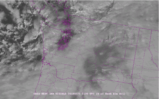
And everything was in place on Sunday afternoon. A front went through that morning resulting in unstable air and cumulus convection moving into the area (see visible satellite image at 1 PM). In the satellite image the convection is shown by the bright clouds, with dark spaces between them, coming in off the ocean.
At the same time, the wind were northwesterly on the coast, with air moving around the Olympics to the north and south, and then converging over Puget Sound--thus producing a Puget Sound Convergence Zone (see surface map at 3 PM). As air converges together, it is forced to rise, which can really rev up clouds and precipitation, particularly when the air is unstable.
As a result, strong convection formed along the convergence zone between Seattle and Everett, something clearly shown by the radar image at 4 PM.
And that convection produced the graupel showers that caused the landscape to whiten. Now to be clear, there was some snow mixed in at higher elevations and where the precipitation was heaviest, but graupel was dominant in most locations.
Finally, graupel is different than sleet or hail. Sleet occurs when rain drops fall into a sub-freezing layer near the ground, resulting in freezing of the rain drops into little, hard ice pellets. Sleet is generally dense and clear. That is not what happened on Sunday. And hail is multi-layered and dense, resulting from ice particles moving up and down several times in intense convection. Not what we had two days ago.
Hail
from Cliff Mass Weather and Climate Blog http://ift.tt/2BT3a3i


No comments:
Post a Comment